
←System Log
Specialized Public Data Relay · Record of deployment01Why
Think about how you got here. You were out in the city, like everyone else, and you noticed something nobody else did. It wasn't a flat sticker. It had depth. You pulled it off the wall, which in New York takes nerve. You turned it over, found a code, and scanned a QR off a random object in the street. Brave. Then a page asked for your camera and you said yes. Braver. Most people stop at the first step. You went all the way to the mask.
That's the whole point of this network. Anyone can wear the mask. Anyone can be amazing. You just proved it on a sidewalk. Now go out and do something great with it.
02Overview
SPDR-BT is a network of physical nodes placed across New York City and carried, by the people who find them, to the rest of the world. Each node links two systems: the Mask, a browser-based augmented reality identity, and the Terminal, a live relay of the city's public data. No accounts, no paywalls, no tracking. In continuous operation since 2020.
03Node specification
Assembly
- 01Body printed in metallic PLA.
- 02NFC chip embedded. A tap opens the Terminal. Added to the build in 2026.
- 03Neodymium magnet inserted. It holds the node to the city.
- 04QR sticker applied to the reverse. One code, shared by every node. A scan opens the Mask and logs the find: position, time, device class.
Placement. During patrol. Streets to rooftops, subway poles to storefronts, wherever the route runs that day. No signage, no instructions. A node is found or it is not.
04Deployment log
- 2020
Program begins as an Instagram augmented reality filter, "Which Spidey Are You?", a randomizer of Spider-Man masks. Generation 1 masks are projection-mapped from in-game photo mode captures.
- 2023
First physical nodes printed and placed in the five boroughs. QR only.
- 2024
Generation 2 masks. Photogrammetry and generative 3D are tested and rejected; the final set is modeled by hand.
- 2025
The Mask moves to WebAR for accessibility and reach: no app, no account, any phone with a browser.
- 2026
The Mask is rebuilt as fully self-hosted WebAR on Three.js, MindAR and MediaPipe. NFC chips join every node. The Broadcast Terminal is released as open source. The public Gallery opens. O.T.T.O., the voice and vision assistant, comes online.
- OCT 2026
Terminal upgrades: Near Me, regional rail, trip planning, radar and lightning, live streams, ferry sailings, satellite passes.
05Field data
- Confirmed finds
- 2,400+
- Cities
- 272
- Countries
- 19+
- New York
- 1,374
- Newark
- 176
- Los Angeles
- 122
- Furthest find
- Melbourne, Australia · 10,361 mi from the first drop
- Deepest run abroad
- Japan · 13 cities
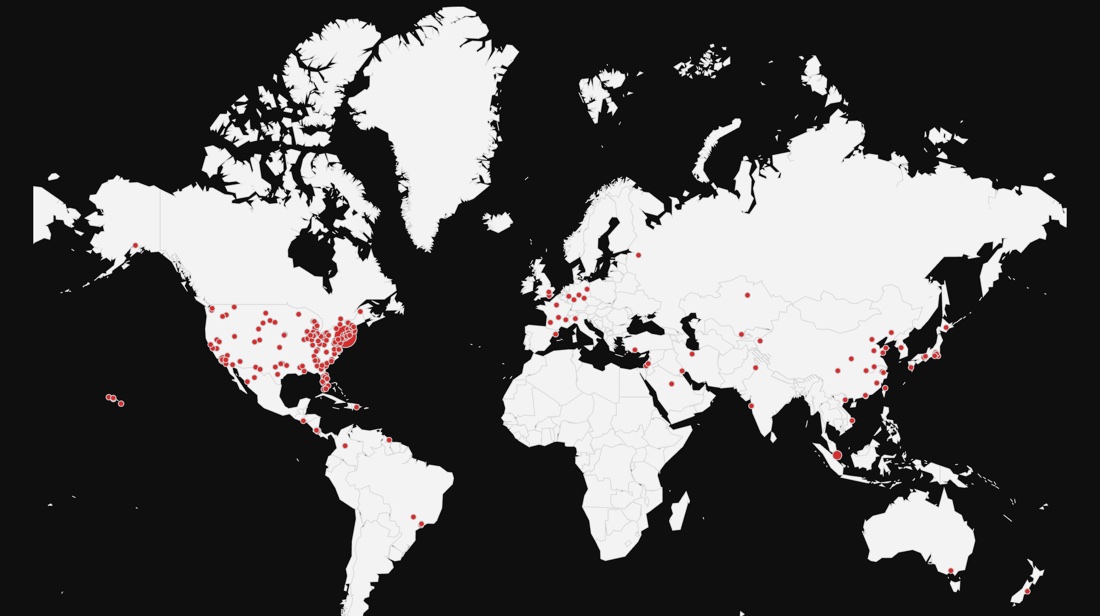
Updated 20 Oct 2026. Hand-delivered nodes and datacenter traffic are excluded.
06The Mask
A scan opens the camera only after the finder chooses to activate. A roulette assigns one of nine Spider Identities: 2099, MCU, TASM2, Raimi, Punk, Spider-Verse, Gwen, India, Symbiote. Face tracking holds the mask in place, with depth occlusion behind hair and glasses. Photo and ten-second video, sharing, English and Spanish. The web-shooter gesture is left for the finder to discover.
Latest transmissions to the public gallery.
07The Terminal
Emergency Relay, Near Me, Weather and Air Quality with radar, News and the WNYC uplink, NYC Events, NYC Cams with 1,000+ DOT feeds and live streams, Traffic, Transit (subway, bus, regional rail, trip planner), Air Traffic, Maritime, Community Board, the Node Map.
MTA real-time feeds, NYC DOT, NYC Open Data, Notify NYC, the National Weather Service, ADS-B, AIS, NYC Ferry, CelesTrak. All public. Location is requested only when you tap for it and is never stored.
08Change log
- 261119_01
- OTTO opens in the camera view. It asks for the camera as the page loads, and your first tap turns on the compass.
- Say no to the camera and OTTO stays on its home screen. The camera button brings the view back.
- The camera view starts with hand and face tracking. Objects and pose are switches along the bottom.
- The camera picture fills the view each time you open it, including when you come back from another app.
- Weapon detection is out of the camera view.
- Commutes on the train tracker. Save a start and an end, and the Subway tab shows the route to take now, when to leave, when you arrive and any alerts on those lines.
- The trip planner leaves out lines that have no trains running, and offers a way around each line on the fastest route.
- Express trains on the train tracker. The trip planner and Commutes follow the trains running now, so an express ride shows a diamond, an Express tag and the stops it makes.
- Station boards tag each train that runs express from that stop, and a line page dims the stops the line is running past.
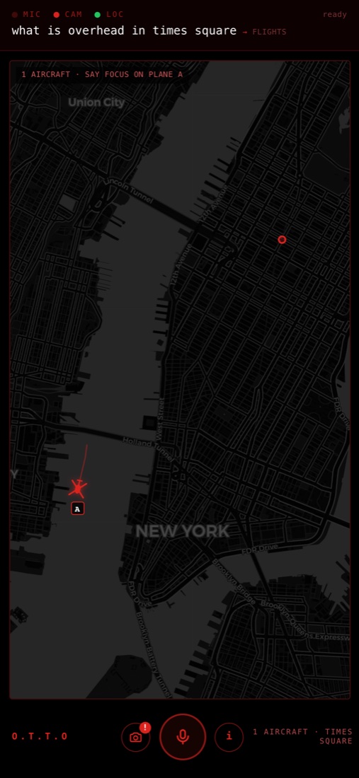
- Aircraft in the OTTO camera view. Point your phone at a plane or helicopter and a tracking box sits on it with the flight, aircraft type, altitude, speed, distance and route.
- OTTO picks the aircraft from your location, the height you stand at and the direction the camera points. Drag the sky to line the box up with a plane, or tap a marker to hold the box on it.
- The OTTO camera view marks only the aircraft in the frame that are close enough to see. Arrows for aircraft outside the frame are gone.
- Tap an aircraft in the OTTO camera view and a sheet opens on it: a photo, the flight and its route, the airframe and its owner, altitude, speed, the autopilot target, its distance from you and its closest pass.
- 261118_01
- NYC Cams fits folding phones and tablets: the live feeds keep their room, and the camera map sits under them as a wide strip showing all five boroughs.
- 261117_03
- Favorite stations: tap the star on a station board and it stays on the train tracker home screen with its next trains.
- The train tracker opens on its home screen each visit, and after half an hour away.
- OTTO asks for camera access when it opens, so the camera button goes straight to the view.
- 261117_02
- Train times count down on screen and refresh every 15 seconds on station boards, Nearby Stations and OTTO, so the minutes you read are the minutes left.
- Terminal stations list the next trains out. Rerouted trains show at the stops they are running through.
- Added the 42 St, Franklin Av and Rockaway Park shuttles and the Staten Island Railway.
- A notice appears on a station board when the MTA feed falls behind.
- OTTO opens sooner: the start screen clears as soon as the mic can take a tap.
- 261117_01
- Helicopters stand out on the Air Traffic map: their own rotor marker, a live count beside the planes, and a tap on that count lights only the helicopters.
09O.T.T.O.
The Terminal's voice. Wake it, ask what is overhead, where the nearest train is, how busy Times Square is. Camera vision reads objects, hands, faces and posture on the device itself; no frame leaves the phone. Aircraft overhead are boxed in augmented reality. A Spectacles build exists. Open O.T.T.O.
10Contact
Found a node somewhere unexpected, want to report a dead one, or have something for the Terminal? Open a channel.